[:sk]Recenzia / NEPOSTREHNUTÝ BRATISLAVSKÝ RING[:en]Review / UNNOTICED BRATISLAVA RING[:]

[:sk]Peter Szalay o výstave Projekt Bratislava vol. 2.: Paralelná Petržalka v Galérii Photoport[:en]Peter Szalay about the exhibition Project Bratislava vol. 2.: Parallel Petržalka in Photoport Gallery[:]

[:sk]

Foto: Ján Kekeli.

Projekt Bratislava je názov nezávislej výskumnej iniciatívy, ktorou architektonické štúdio PLURAL mapuje svoje rezidenčné mesto. Podľa definície Michala Janáka a Martina Jančoka, vedúcich osobností štúdia, sa jedná o „dokumentačno-špekulatívnu  iniciatívu“,  ktorej cieľom je „dôsledne čítať“ existujúcu štruktúru  mesta a hľadať v nej charakteristické črty, ktoré ďalej môžu využiť vo vlastnom plánovaní. Ak sa architekti svojim prvým výskumným vstupom s názvom Hypotéza & realita (2017) pokúsili zachytiť celkovú fyzickú stopu mesta v podobe rozmerného „schwarzplánu“, aktuálne bádanie zamerali už len na vybranú časť mesta, Petržalku. V novom projekte, Paralelná Petržalka prezentovanom vo forme výstavy v galérii Photoport, už ďalej nepokračovali v práci s čiernobielym rastrom zastavaných a voľných plôch, za objekt svojho skúmania či čítania si zvolili konkrétnu líniu cesty – okruhu, ktorý obopína najznámejšie sídlisko Slovenska.

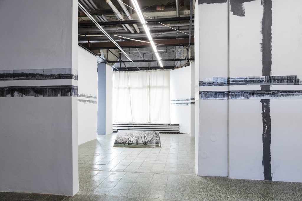
Prechod z vtáčej perspektívy k pohľadu chodca po nevytýčenom Petržalskom ringu vizualizovali jednoduchým, zrkadlovo rozloženým pohľadom „uličnej“ fronty. Dva rovnobežné pásy fotografií s prázdnou osou cesty, tvorili hlavný prvok výstavy prezentovanej v Petržalskej galérii Photoport. Autori v línií okruhu, ktorý obehol členitý priestor stien galérie, odprezentovali kompletný fotografický zápis rôznorodých urbánnych a krajinných prvkov okolia tejto významnej dopravnej infraštruktúry.  Odhalili tak prehliadanú všednú realitu miest po ktorých síce na autách denne prejdú tisícky ľudí, no málo kto z nich tento priestor reflektuje inak ako tranzitný koridor. Neprikrášleným, suchým fotografickým záznamom reality okruhu tak architekti odhalili neplánovitý, rastlý charakter tejto lokality, ktorý sa pritom v mapovej mierke javí ako jasný urbanistický zámer, ako ideálny ring okolo Petržalky.

Paradox PLURAL-om skúmanej lokality však nespočíva len v dvojakom videní „Petržalského ringu“, ale aj v samotnej fragmentárnosti tohoto urbanistického konceptu. V aktuálnom územnom pláne a v podstate aj v predchádzajúcich urbanistických plánoch datovaných vznikom novej Petržalky je tento ring integrálnou súčasťou plánu Bratislavy, napriek tomu nevznikla dodnes ucelená vízia, ktorá by architektonizovala okruh ako celok, či aspoň jeho väčšie časti. Prehliadanie tejto cestnej línie plánovačmi a aj architektami potvrdzuje aj doplňujúci materiál k výstave – súbor faksimile textov o plánovaní Petržalky. V tejto vyčerpávajúcej rešerši dobových magazínov, ktorú architekti umiestnili na sokel v kúte galerijného priestoru nájdeme len veľmi málo zmienok o tejto okružnej komunikácii, väčšina textov sa orientuje na celkový plán mestskej štvrti, alebo na riešenie „centrálnej rozvojovej osi“ prechádzajúcej stredom sídliska.

Prezentácia formou rozloženej uličnej fronty je obvykle využívaná pri ukazovaní kompaktnej panorámy ulíc, či bulvárov. Jej aplikovaním na Petržalský okruh PLURAL umocnil skutočnosť, že obe jej strany nie sú vnímané ako celok, že architektonické projekty vznikajú akosi povedľa tejto dopravnej tepny a nie na nej. Väčšina zo stavieb cestu, pri ktorej vznikli, ignorujú, vytvárajú indiferentné štruktúry, obracajú sa ku komunikácii fasádami pri ktorých nie je celkom jasná ich orientácia (najlepšie vystihuje prístup neskoro postmoderná budova Daňového úradu), iné sa od nej oddeľujú, chránia bariérami a technickými podlažiami, prijímajú drive-in stratégiu s charakterom diaľničnej infraštruktúry (ako je na príklad Obchodný dom Atrium od Ľubomíra Závodného, alebo vedľajšie fitness Relax od Andrei Klimkovej). V prípadoch keď pracujú s oboma stranami cesty sa však túto líniu usilujú čo najviac potlačiť, prekonať (spomeňme víziu architekta Vladimíra Dedečka premostiť výstavisko Incheba so sídliskom rozsiahlymi plochami terás, alebo nedávne úsilie o prekrytie Einsteinovej ulice ľúbivou krajinnou štruktúrou ateliéru Šebo a Lichý).

Polohy ľudskej živelnej aktivity, generovanej viac ekonomickým potenciálom než racionálnym plánovaním, by sa tak zdanlivo mohli podobať podobne živelným prvkom lesov, či náletových plôch s pozostatkov nerealizovaných stavebných plánov. Tieto prírodné ostrovy, ktoré lemujú významnú časť predstaveného okruhu však v sebe nesú významný potenciál siahajúci za nutkavú potrebu nekonečnej inovácie a rastu.

Autori „Paralelnej Petržalky“ sa držia svojej zásady dokumentovania, neprejavujú ambíciu projektovať,  len v určitých vybraných miestach podľa charakteru krajiny a architektúry pripájajú referencie slávnych architektonických návrhov. Opatrne tak naznačujú vlastný názor na ich formovanie, stále v ňom však pretrváva poloha pozorovateľov, ktorý si snažia uchovať objektivizujúci odstup. Ich autorským gestom a vyjadrením je už samotné vizualizovanie nepovšimnutého ringu, architektonizovanie tohto útvaru, čím sa má stať ďalej formovateľným.

Na Slovensku je zriedkavé aby projektujúci architekti skúmali, mapovali terén svojho mesta ako iniciatívu k vlastnej tvorbe. Vo svete k takémuto vlastnému skúmaniu nájdeme rad referencií, samotní architekti štúdia PLURAL sa od začiatku Projektu Bratislava odvolávajú predovšetkým na dlhodobý výskumný projekt O. M. Ungersa o Berlíne. Ungers svoje návrhy, na ktorých v sedemdesiatych rokoch pracoval spolu so svojimi študentami na Cornelovej univerzite, publikoval v knihe Mesto v meste: Berlín: Zelené súostrovie (1977). Ungers týmto projektom reagoval na zmršťovanie a vyľudňovanie miest svojej doby a jeho kniha sa rýchlo stala manifestom pre uchopenie tohto procesu. Charakteristikou súčasnej Bratislavy však nie je zmršťovanie, naopak zažíva masívny stavebný boom. Mesto sa už dlhšiu dobu rozlieva do krajiny a v posledných rokoch sa aj stále viac zahusťuje vo svojom vnútri. Ungers reagoval na vtedajšie globálne udalosti, ropné krízy a nástup neoliberálnych politík, privatizácie verejného priestoru, ktoré iniciovali premyslenie verejného záujmu v meste a viedli k formulovaniu Lefebrvových téz práva na mesto.

V dnešnej dobe si stále akútnejšie uvedomujeme komplexnosť týchto práv, ktoré už nemôžu zahŕňať len ľudí ako druh. Globálna klimatická zmena nás núti hľadať súlad v koexistencii s čo najširším spektrom živých organizmov a entít nevyhnutných pre našu existenciu. Hľadať spôsob života medzi druhmi ako predostiera Rossi Braidotti sa tak zdá byť nevyhnutný pre žitie spravodlivého sveta.
Jediný centrálne umiestnený objekt v priestore galérie, fotografia prírody temer bez náznaku civilizácie od Jána Kekeliho nepochádza zo skúmaného ringu, ale z dlhodobo diskutovanej centrálnej petržalskej osi. Podobne ako na petržalskom okruhu aj v jej centre ešte prežíva divoký nearchitektonizovaný a neregulovaný biotop, ktorý tu zdanlivo bez prekážok bujnie. (Rôzne stavebné projekty od silne medializovaných ako je Nové lido, a spomínanej centrálnej rozvojovej osi až po tie „ututlávané“ ako je snaha zástavby lokality Pečianskeho ramena a pohraničných zón však spochybňujú tento pokoj). Melancholickú Kekeliho fotografiu tak môžeme čítať ako metaforu, ale aj ako výzvu potreby radikálneho premyslenia konceptu práva na mesto a toho či sme my ľudia jeho výhradnými nositeľmi.

Projekt Bratislava vol. 2.: Paralelná Petržalka
Galéria Photoport, 28. 12. 2018 – 10. 1. 2019
Autori: Martin Jančok, Michal Janák, Zuzana Kovaľová, Ruslan Dimov + Ján Kekeli
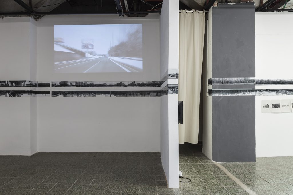
Foto: Ján Kekeli.
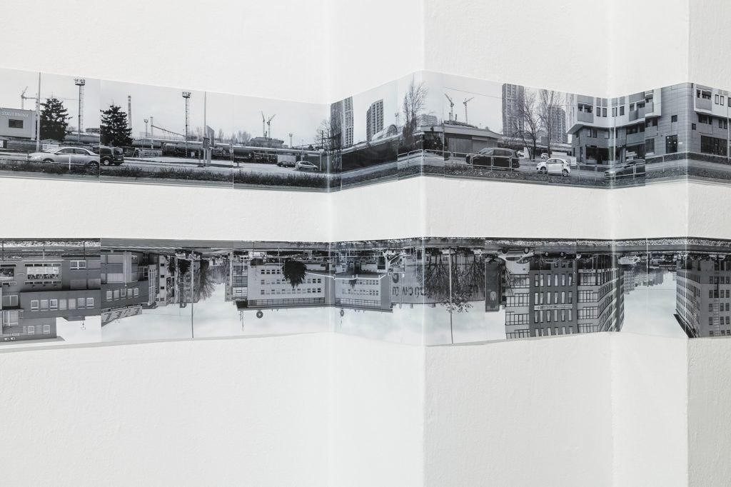
Foto: Ján Kekeli.

 [:en]

Photo: Ján Kekeli.

Project Bratislava is the name of an independent research initiative by which the architectural studio PLURAL is mapping its residential city. As defined by Michal Janák and Martin Jančok, the studio’s leading figures, it is a “documentary and speculative initiative”, the aim of which is to “rigorously read” the existing structure of the city and to look for characteristic features in it, which they can then use in their own planning. If the architects’ first research entry, Hypothesis & Reality (2017), attempted to capture the overall physical footprint of the city in the form of a dimensional ‘schwarzplan’, their current research has focused only on a selected part of the city, Petržalka. In their new project, Parallel Petržalka, presented in the form of an exhibition at the Photoport gallery, they no longer continue to work with the black and white raster of built and open spaces; they have chosen a specific line of the road as the object of their investigation or reading – the ring road that encircles the most famous housing estate in Slovakia.

The transition from the bird’s eye view to the pedestrian’s view along the undefined Petržalka Ring was visualized by a simple, mirror-spaced view of the “street” front. Two parallel strips of photographs with an empty axis of the road, formed the main element of the exhibition presented in the Petržalka Photoport Gallery. In the line of the circle, which circled the articulated space of the gallery walls, the authors presented a complete photographic record of the diverse urban and landscape elements surrounding this important transport infrastructure. In doing so, they revealed the overlooked everyday reality of cities that, while thousands of people pass through daily in their cars, few of them reflect on this space in any other way than as a transit corridor. With an unadorned, dry photographic record of the reality of the ring road, the architects have thus revealed the unplanned, sprawling nature of this location, which at the same time appears on a map scale as a clear urban plan, as an ideal ring around Petržalka.

However, the paradox of the site studied by PLURAL does not only lie in the double vision of the “Petržalka Ring”, but also in the very fragmented nature of this urban concept. In the current zoning plan, and in fact in previous urban plans dating back to the creation of the new Petržalka, the ring is an integral part of the plan of Bratislava, yet no coherent vision has emerged to date that would architectonise the ring as a whole, or at least its larger parts. The overlooking of this road line by planners and architects alike is confirmed by the exhibition’s supplementary material – a set of facsimile texts on the planning of Petržalka. In this exhaustive search of contemporary magazines, which the architects have placed on a plinth in a corner of the gallery space, we find very few references to this circular road; most of the texts focus on the overall plan of the urban district, or on the solution of the “central development axis” running through the centre of the estate.

The presentation in the form of a staggered street front is usually used when showing a compact panorama of streets or boulevards. By applying it to the Petržalka ring road, PLURAL has reinforced the fact that both sides of it are not perceived as a whole, that architectural projects are somehow created next to this thoroughfare and not on it. Most of the buildings ignore the road along which they were built, creating indifferent structures, turning towards the road with facades whose orientation is not quite clear (the late postmodern Tax Office building best describes the approach), others separate themselves from it, protect themselves with barriers and technical floors, adopting a drive-in strategy with the character of motorway infrastructure (such as the Atrium department store by Ľubomír Závodný, or the Relax fitness centre next door by Andrea Klimková). In cases where they work with both sides of the road, however, they try to suppress this line as much as possible, to overcome it (think of the vision of architect Vladimír Dedeček to bridge the Incheba exhibition centre with the housing estate with large areas of terraces, or the recent efforts to cover Einstein Street with a pleasing landscape structure by the Šebo Lichý studio).

The locations of human elemental activity, generated more by economic potential than by rational planning, could thus seemingly resemble similarly elemental elements of forests or riparian areas with remnants of unrealised building plans. However, these natural islands that line a significant part of the imagined circuit hold significant potential beyond the compelling need for endless innovation and growth.

The authors of “Parallel Petržalka” stick to their principle of documenting, they do not show any ambition to design, they only attach references of famous architectural designs in certain selected places according to the character of the landscape and architecture. In this way, they cautiously indicate their own opinion on their formation, but the position of observers, who try to keep an objectifying distance, still persists. Their authorial gesture and expression is itself a visualisation of the unnoticed ring, an architectonising of this formation, making it further formable.

In Slovakia it is rare for designing architects to explore and map the terrain of their city as an initiative for their own creation. In the world we can find a number of references to such self-exploration, the architects of PLURAL studio themselves, since the beginning of Project Bratislava, refer mainly to the long-term research project O. M. Ungers on Berlin. Ungers published his designs, on which he worked with his students at Cornell University in the 1970s, in the book The City in the City: Berlin: a Green Archipelago (1977). With this project, Ungers responded to the shrinking and depopulating cities of his time, and his book quickly became a manifesto for grasping this process. The characteristic of contemporary Bratislava, however, is not shrinkage; on the contrary, it is experiencing a massive building boom. The city has been spilling out into the countryside for some time, and in recent years it has also become increasingly denser within itself. Ungers was responding to global events at the time, the oil crisis and the advent of neoliberal policies, the privatization of public space, which initiated a rethinking of the public interest in the city and led to the formulation of Lefebvre’s thesis of the right to the city.

Today, there is an increasingly acute awareness of the complexity of these rights, which can no longer just include people as a species. Global climate change is forcing us to seek harmony in coexistence with the widest possible range of living organisms and entities essential to our existence. To seek a way of living among species as Rossi Braidotti proposes thus seems essential to living a just world.
The only centrally located object in the gallery space, Ján Kekeli’s photograph of nature almost devoid of any hint of civilization, comes not from the ring under study, but from the long-discussed central axis of the Petržalka. Similarly to the Petržalka ring, the wild, unarchitected and unregulated habitat still survives in the centre of Petržalka, seemingly unhindered by obstacles, and thrives there. (Various construction projects, however, from the highly publicized ones such as the New Lido and the aforementioned central development axis to the “hushed up” ones such as the efforts to develop the Pečianske ramen site and the border zones, call this tranquility into question). Kekeli’s melancholic photograph can thus be read as a metaphor, but also as a challenge to the need for a radical rethinking of the concept of the right to the city and whether we humans are its exclusive bearers.

Project Bratislava vol. 2.: Parallel Petržalka
Photoport Gallery, 28 December 2018 – 10 January 2019
Authors: Martin Jančok, Michal Janák, Zuzana Kovaľová, Ruslan Dimov + Ján Kekeli

Photo: Ján Kekeli.

Photo: Ján Kekeli.

[:]

5 / 3 / 2019
by Peter Szalay
[:en]Share on Facebook[:][:sk]Zdieľaj na Facebook[:]