THE PEDESTRIAN’S VENICE
Peter Michalík about project THE PEDESTRIAN'S VENICE, 2017 by Roberto Casati, Magda Stanová, and Stéphanie Roisin.

Cover. Photo: Peter Simoník
Cities with a characteristic spatial structure can be reliably identified in a flash of an eye; we recognise New York, Paris or Barcelona based on their typical street scheme without any help of looking at some of their architectural dominants. One of the cities like that – with a bold and easily recognisable urbanist structure – is undoubtedly Venice. But in contrast with the abovementioned examples, it is not the network of streets that form the ideogram of the Italian city, the frame of its visual representation, yet the network water canals. Primarily the Canal Grand which sears the body of Venice with its distinctive form recalling a letter “S”. On the contrary, we fail to find any characteristic sign in the city street grid, i.e. in the zones assigned for pedestrian movement or surface motorised transport, on the contrary. This in many ways tells us a lot about an important role of water transport in the city from the moment of its founding. A substantial part of trade and social dynamics in Venice has taken place on water since its birth. One still may find evidence for it in the orientation of the entrances of major city edifices opening not towards the street, as the logic of our everyday experience with a city would suppose, but towards the canals, which from a pedestrian’s view seemingly leads to a void. Historically speaking, we may see the confirmation of this preference also in old maps and tour guides where the names of canals and streets do not get equal treatment. This fact is brought forward also by Magda Stanova, the author of the project titled Pedestrian’s Venice (in cooperation with Roberto Casati).
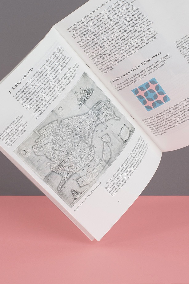
Photo: Peter Simoník
At its base lies the idea of the city whose image is created mostly by movement on a water surface. Evident from the title, the meaning of the project is to confront this idea with a new observer‘s angle, revealing a context that determines the way of perception of the city from a pedestrian’s perspective. It may seem that the crowded Venetian streets, as possible the only pedestrian routes in Europe in need to be regulated by a police officer during a peak hour, challenges the image of Venice as a city that undermines or even represses the pedestrian movement. You only need to leave the most exposed tourist routes and the strategies of movement a visitor has acquired in other European metropoles suddenly stop being applicable. Everyone who has ever moved in the Venetian streets without a tour guide knows how the city resists, in form of unexpected obstacles, water barriers and dead ends. The point of departure of the idea to map the Venetian street network could easily be a need coming out of a trivial experience of a pedestrian in Venice, who strives to get from his/her current position to a particular, relatively distant destination. The ambition of the creators, however, reaches substantially further than to meeting a practical need of orientation in a puzzling city labyrinth: the Venice map is in this case more of an accurate spatial representation in a traditional sense of the word, being rather a scheme that a pedestrian may perceive as a field of options of his/her own, perpetual movement. While devising the plan, the creators worked with their own “spatial unit” – a block they defined as a space that can be walked continuously around the circumference, but not through, thus substituting a street that often steers a pedestrian into its dead end. This specific “ability” of Venice was repeatedly confirmed also in the research stage of the process, in which the author decided to complete a sort of mystically sounding assignment – to walk all the streets of the city and register the moments hampering a continuous movement in order to eventually exclude them from her design. The map constructed in this manner, rid not only of their dead ends, but also spaces admissible only for fee, or in a certain limited part of the day (parks and public gardens), spaces admissible to a common visitor only after breaking some rule, or by overcoming some visible physical barrier (a sign, a road block) turns this body of often disconnected streets into an interconnected network similar to the network of water canals. The outcomes of the Magda Stanova’s project are all the more interesting, as an interest in the city from a pedestrian’s perspective led to a full-fledged expression in a form of an ambitious artistic project published in the monographic edition of the Magazine X about contemporary drawing. The project transfers the field observations into a series of visual recordings open to mutual overlaps and comparisons. One of the intriguing feats is a translation of the research outcomes into the Venice plan from 1729 by Ludovico Ughi, resulting in the knowledge that even such a city-museum as Venice, rather than being a static city fossil, is a living organism subject to changes and spatial transformations challenging the semblance of a closed system of a construction project. The most remarkable proof of it is a fact (a symptomatic one, given the topic) that the historical document does not comprise several streets of the recent plan: they emerged in the city, formally predetermined by trajectories of water transport, in place of disused, buried water canals. The Magda Stanova’s project thus draws our attention to, among other factual observations, not quite an obvious thing: we can perceive walking – as one of the few things easier done than said – not only as a verified tool to “read” or “decode” a city landscape rich in meanings, but, eventually, also as a tool of its particular physical transformation.
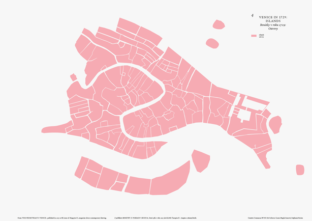
Map 4, Venice in 1729: ISLANDS